Sep 4, 2012

Christchurch Thunderstorm

Doesn't happen too often here, so great to watch it when we get one.


Aug 14, 2012

Hengistbury Head

With it's seemingly impossibly high cliffs and a scary slippery path climbing it's face, Hengistbury Head was always one of my favourite places to visit at the weekend. It was fitting then that whilst visiting my parents in the UK we had the chance to take Martin there. The cliffs were no longer as steep and tall of course and the scary path has long since disappeared in the face of continued erosion, but the headland and spit is still a very special place to visit. There is a very good website http://www.hengistbury-head.co.uk  which has a lot of detail about the history, geology and some ecology of the area.


 There are three routes to choose from on the headland. Firstly the beach itself, then the hilltop and finally the private road behind the hill that the 'train' runs along.  We walked out along the beach and rounded the long groyne, before stopping for morning tea at the cafĂ© and then shortly afterwards lunch on the beach. The water of the Solent was much warmer than I remembered and I managed a decent dip.
From the top of Hengistbury Head - looking along the spit.
Beach Huts.
More Beach Huts.
With with parents on top of Hengistbury Head.
The historic Black House.

Beach Hut Alley.
We made it all the way out to Mudeford Spit, before returning past the Black House. We walked back over the hill which gives great views out over the Solent, Bournemouth and the surrounding area. You can also spy on the trains from the viewpoint at the top without having to walk back along the road.
Looking back to Mudeford Spit and Christchurch Harbour.
The view down to the beaches.
Christchurch Priory.


Aug 9, 2012

Dolomites - Fanes


Our final walk in the Dolomites was a simple trip up to the Fanes restaurant hut from Pederu. We had hoped to stop at Lago Ju de Limo to sunbath, but the weather closed in, so we opted instead for a nice lunch at the hut. The most shocking thing on this walk was the water level in the lake compared to two years ago. It almost looked like somebody had put a pump in and drained it.


Rocky spires on the way up from Pederu.

Climbing towards the lake, with Fanes behind.

An almost empty Lago de Limo - August 2012
Lago de Limo - July 2010

Choosing lunch in Fanes.

One of the huts, just below Fanes.

Start of the 4WD track down to Pederu.


Final descent to Pederu.

Aug 6, 2012

Dolomites - Monte Muro Mauerberg


An easy warm up walk to Monte Muro Mauerberg from Pe de Borz. We walked up to the Refugio Monte Muro Mauerberghutte for morning tea before lunching on the summit. The lower sections were all pine forest, but higher up there were good views across to the Putia massif, where we had walked round in 2010.


Just above the hut, with Putia's summit poking in to the clouds.

A long lazy lunch on the summit.

Heading back down to the hut.

Approaching Refugio Monte Muro Mauserberg.

Jul 22, 2012

Mingha - Edwards


I returned to Arthurs Pass in July and tramped a route that I last walked over six years ago, also in winter. I headed up the Minga Valley to Goat Pass before crossing to the Edwards via the Taruahuna Pass.


From the car park just north of Greyneys Shelter, I immediately forded the Bealey and Mingha Rivers, then headed up the true right of the Mingha River. The first part of the route is a bit of a gravel bash in the wide, open valley but it slowly narrows as you head up stream. It is normal to ford the Mingha when the river undercuts small bluffs, but I managed to sneak around them and avoid fording.

Heading towards Dudley Knob, I picked up the well defined tramping track which climbs away from the river. Despite the recent winter storms there was very little windfall on the track and I made good progress all the way to the Mingha Bivouac. DOC have clearly spent a lot of time maintaining this track, no doubt reflecting the tracks huge popularity. Several sections have cut staircases and in places a material track bed has been added to minimise erosion.
Mingha Biv.
 After a brief morning tea stop at the slightly damp Biv, I continued up to Goat Pass. The track above the biv soon leaves the bush and climbs through an area of tussock mixed with alpine scrub. A short distance below the pass there is one last crossing of the now infant Mingha River.

Goat Pass - hut is bottom centre.
From the high point where the path sidles in towards Goat Pass hut, I left the path and climbed the ridge towards Lake Mavis. The initial section of this climb is reasonably steep and there are a number of options involving either scree or scrub to choose from. Further up I picked up some cairns which indicated a route across the shoulder of the ridge to Lake Mavis. There are good views across to the Temple Col from here.

Mount Franklin ridge.
Flat light on a frozen Lake Mavis.
The Temple Col from above Lake Mavis.
The lake itself was snowed in and with very flat light it was hard to make out any distinguishing features of it or take a good photograph. At this point I encountered true winter conditions and the ice axe and crampons were needed until reaching Taruahuna Pass. I gained the north ridge of Mount Oates by sideling under Point 1978 before dropping down good snow slopes in to the basin under this subsidiary top.
Camped below Mount Oates (i).

Camped below Mount Oates (ii).
Camped below Mount Oates (iii - Sunday morning)
I camped here and enjoyed a good dawn over the Tarn Col and Falling Mountain before making my way down to Taruahuna Pass. The key to this route is to cross the terraces north east of the basin and not to get caught up in the steep ground and cliffs near the stream that drains from the basin's small tarn. Nether the less there was still one short awkward descent before reaching easier ground and the pass itself. The pass itself also marked the snowline.
The Falling Mountain from Mt Oates camp.
The Tarn Col and Falling Mountain.
Taruahuna Pass from the Upper Edwards Valley.
Falling Mountain and The Amber Col.
 The upper Edwards is one of my favourite areas of the National Park and I made good progress down to the Edward's Hut, whilst enjoying the scenery of the Polar Range and Amber Col. I stopped for morning tea at the hut - the hut log book had recorded no visit for over one month.  From here, on very familiar ground now, I picked up the normal tramping route down the Edwards River, an easy three hour tramp back to the car, with just small fords of the East Edwards and then the Bealey, Minga and Edwards rivers to cross en route. 
Frozen Tarns and the Edwards Hut.

May 13, 2012

Woolshed Hill and an attempt on the Savannah Range

With a trip to Greymouth for work, I took the opportunity to have another attempt at the Savannah Range traverse, our previous two attempts having been stopped by  waist deep snow the first time and strong winds the second.

I left the Hawdon Shelter at a little after 16:00 on the Friday evening after a brief chat with a couple of hunters heading up Sudden Valley. Climbing at a reasonable pace, I reached the first tarn, which was to be my campsite for the night at around 17:30. The tarn was a bit more exposed than I remembered it, being completely unprotected to any westerly winds. Luckily the night was completely still. It was pitch dark before I finished dinner and the temperature dropped rapidly too. I hit the sack pretty quickly.

Mount Binser from near the Hawdon Shelter.

Woolshed Hill Track.
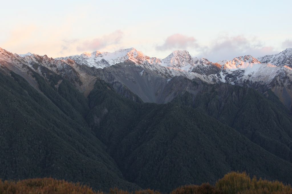
Late evening over the Waimakariri River and Black Range.

Last daylight from Woolshed Hill.

I was up early on the Saturday morning. It would have been pretty fresh overnight as there was frost on the inside of the tent. I spent a while watching the sunrise on the Polar Range before heading off.

First light on the Black Range.

Morning Sunlight on the Black Range.
Sudden Valley from Woolshed Hill.

The Polar Range.

Woolshed Hill campsite.

Up to point 1520 the range traverse is straightforward, though there is a fair amount of descending and climbing , including a drop right down to the bush line just before point 1520. I stopped for lunch just after this top to survey the route ahead.

Sugar Loaf and Cass Hill from Woolshed Hill.

Mount Binser from Woolshed Hill.

From here the ridge changes in character. I sidled across the face below point 1676, but regaining the ridge I encountered some fresh loose snow on the ridge. The ridgeline narrowed a lot at point 1657 and the wind had got up making balance unsteady. The guidebook talks about sidling around this on steep scree, but it looked very uninviting and slippery from where I was and I calledit a day at this point. Maybe after three goes I should give up on this range traverse?

Point 1676 on the ridge traverse. I sidled across the face to avoid the bluffs (L)

I back tracked a little and then dropped down in to the Andrews Stream off of point 1478. A recently used (like yesterday) deer trail made the descent very straightforward. I camped at one of the many sites in the Andrews Valley at the bottom of Hallelujah Flat, a much warmer nights sleep than the previous evening.

Looking towards Point 1657 on the Savannah Range.

East Hawdon watershed with Mount Valiant in the background.

Ridge around point 1657. The narrowest section is in the centre of the image.
Sunday was a simple but very wet walk out to the Mt White  Road. I was lucky enough to be picked up by a Possum Hunter at 9:00am on a gravel road in the middle of nowhere, who was kind enough to give me a ride back to the Hawdon Shelter. With this shortcut I was back in a sunny Christchurch for 11:30