I left the Hawdon Shelter at a little after 16:00 on the Friday evening after a brief chat with a couple of hunters heading up Sudden Valley. Climbing at a reasonable pace, I reached the first tarn, which was to be my campsite for the night at around 17:30. The tarn was a bit more exposed than I remembered it, being completely unprotected to any westerly winds. Luckily the night was completely still. It was pitch dark before I finished dinner and the temperature dropped rapidly too. I hit the sack pretty quickly.
Mount Binser from near the Hawdon Shelter.
Woolshed Hill Track.
Late evening over the Waimakariri River and Black Range.
Last daylight from Woolshed Hill.
First light on the Black Range.
Morning Sunlight on the Black Range.
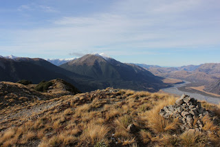
Sudden Valley from Woolshed Hill.
The Polar Range.
Woolshed Hill campsite.
Sugar Loaf and Cass Hill from Woolshed Hill.
Mount Binser from Woolshed Hill.
From here the ridge changes in character. I sidled across the face below point 1676, but regaining the ridge I encountered some fresh loose snow on the ridge. The ridgeline narrowed a lot at point 1657 and the wind had got up making balance unsteady. The guidebook talks about sidling around this on steep scree, but it looked very uninviting and slippery from where I was and I calledit a day at this point. Maybe after three goes I should give up on this range traverse?
Point 1676 on the ridge traverse. I sidled across the face to avoid the bluffs (L)
East Hawdon watershed with Mount Valiant in the background.
Ridge around point 1657. The narrowest section is in the centre of the image.
Sunday was a simple
but very wet walk out to the Mt White
Road. I was lucky enough to be picked up by a Possum Hunter at 9:00am on
a gravel road in the middle of nowhere, who was kind enough to give me a ride
back to the Hawdon Shelter. With this shortcut I was back in a sunny
Christchurch for 11:30


