Jun 26, 2010

Bear Country - Hiking Denali.

After finishing the canoe trip out of Whittier, we stopped off at Denali National Park on the way back to Fairbanks. This National Park is massive - bigger than the state of Massachusetts's, and access is limited to one gravel road that runs some 95 miles in to the interior. During the summer you can only use this road by taking the bus system that drops you off at your hike.


The park is divided up in to different zones and numbers to each are strictly limited. As you can't book a zone in advance, it is something of a lottery as to which areas are available to hike in. I thought that I would hate this kind of restricted system, - however the necessity of it quickly becomes obvious. The park is a true wilderness with no trails or facilities at all and without some sort of restrictions the place would be overwhelmed.

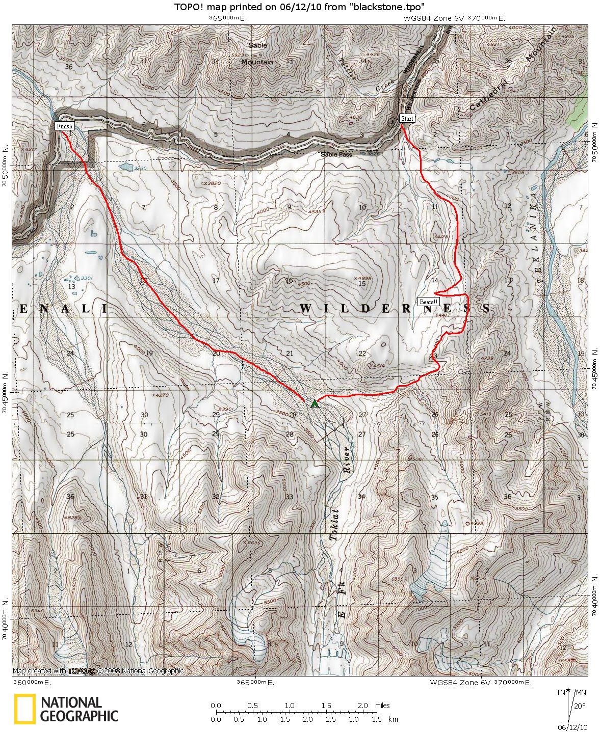
On the advice of the ranger we ended up with zone 8, which sits behind a critical wildlife zone, so there is no access directly from the road (this is OK though, you can start in a different zone as long as you camp in your zone.)

After dropping down the road to the river we were immediately in bear country. The scrub was thick enough to hide bears and the wind was against us. Good enough reason to start shouting.

Up on the ridge we relaxed a little, but then as we started sidleing around the side of point 4739 we spotted brown moving shapes in the distance. Grizzlies! A mum with two cubs.

We altered course to avoid them, and ended up contouring much higher than we had first thought. A trip in to the side valley was cancelled, when another bear spotted us before we saw it and headed off in that direction.

Instead we headed down to the Tolkat River Valley to camp, a nice location with much less bear sign and good views in each direction. We adopted proper camping procedures for bear country, cooking 100m away from the tent and storing the food also 100m away to make a nice triangle.

The next day was wet, so we walked out to the road mid morning. This gave us time to catch the bus further in to the park, where we spotted more bears and even some wolves.

Jun 13, 2010

Prince William Sound - Sea Canoeing

I flew to Alaska a couple of weeks before Alan's Wedding to do a mixture of canoeing and tramping with him. Our first trip was sea canoeing in Prince William Sound.


Just getting to the launching point at the town of Whittier is an experience. It is accessed by single lane road tunnel which has 15 minute traffic flow in each direction. The railway also shares this tunnel with the road. The town itself is very small, we were surprised to find snow down to sea level here, as even in the Alaskan Interior most of it had already gone.


We set out down the Passage Canal in pretty calm conditions and paddled about three hours on the first day, passing Shotgun Cove, where as the name suggests, we were blasted by gusts of winds coming over from the next bay. We camped at Decision Point the first night, being the weekend there were a number of other groups there, including an instructor who seemed somewhat concerned that we had an open canoe in a "Marine Salt Water Environment"


The sea was flat calm the next day and we rounded the point and headed in to Blackstone Bay to have a look at some calving sea level glaciers. This was a big day and it was afternoon by the time we reached them. This area is truly spectacular. We messed around on the edge of the "pack ice" for a bit being careful not to get too close to the ice bergs that kept turning over as they melted. A capsize in Prince William Sound would be very serious as the water temperature was only a couple of degrees above freezing.


We headed back towards Decision Point, but stopped short and camped at a delightful knoll by a small beach. We had views right down to the glaciers and as it doesn't really get dark here at this time of year, we could sit and watch them in beautiful light.


The third day we headed back to Shotgun cove and camped. In the afternoon we took a short walk climbing to the saddle above the cove to look back over in to Blackstone. There were fresh bear prints here too.


The final day was short and the weather had started to deteriorate. There was just enough chop to make it interesting as we canoed back to the town for a fish and chips lunch, before setting off along the Seward highway for Denali.

May 30, 2010

First Footing

Winter has arrived in New Zealand. After the worst week of weather for ages we finally got a chance to play in the snow today with a quick trip up Foggy Peak from Porters Pass.


Starting at over 900m meant we didn't have to get out of bed early. A simple two hour walk saw us at the top of Foggy Peak, with reasonably solid snow for the last few hundred metres. It was cold and miserable on the way up with a mixture of rain / ice and wind blown snow but the sun appeared miracuously on the summit and we could see over to Castle Hill Peak. We'll come back later in the season and do the traverse I hope.


It was fun (trying to) ski down. I see that my skiing hasn't improved much. Finally went back to walking a couple of hundred metres above the road, as the snow became too soft and I kept cart wheeling.


This year we miss the Main Act for the NZ winter, but we'll be back for the encore. Hopefully it sticks around a bit.

May 16, 2010

Little Mt Peel

Another day trip this weekend – to Little Mount Peel. We’d planned on camping at the DOC campsite in Peel Forest Park, but it had closed for the winter, so we ended up coming back to Christchurch late on Saturday. The best laid plans…


We took the Deer Spur track up to the summit, climbing in the sunshine whilst a growing blanket of cloud was smothering the plains. A couple of people were already on their way down. Near the summit we overtook a family with some enthusiastic kids, the oldest could have been no more than ten.
After enjoying a lunch in the warmth of the summit sunshine, we dropped down the steeper south ridge route on the return already in shadow. The ridge is open with a great feeling of space and you descend steeply towards the plains.
A quick diversion to the Emily Falls at the end saw us back to the car after a relaxing six hour round trip.

May 9, 2010

Mt Vernon

A quick trip to the summit of Mt Vernon this morning.


Up the Mt Vernon farm track and down the top of Rapaki then the Valley Track. Good to see lots of people out walking, running and mountain biking. Such a warm day, reminded me of the summer we never had.

Great views from the top. Over the Lyttleton side:


And back to the City :

The Grand Duchess

From 1st - 2nd May

A week of rain on The Divide (over 500mm at Carrington Hut apparently) saw us heading for Lewis Pass for the first time in a while. After not having been out for a couple of weeks we wanted something fairly challenging and decided to have a look at the Grand Duchess.


An early morning start from Christchurch saw us at Palmer Lodge well before 10:00am. We were on familiar territory up the Nina Valley until the first footbridge, before picking up the ‘old’ track, staying on the true left of the river. We stopped shortly afterwards – the sun had made it to the flats by then, and were surprised to be passed by a guy almost immediately. He must have been on a mission as he disappeared almost as quickly on the other side of the flats.


The track up to the Lucretia Stream is probably even nicer than the main Nina Valley Track. The track is on the flats more often, giving better views of the Nina. Once we reached the Lucretia Stream the character changes again, the bush becomes thick and a little reminiscent of The Coast.


We stopped at Lucretia Hut for lunch, again on flats in the sun and were then pleased to find a well marked and cut route (not mentioned in the guide) that took us out on to the tops, with great views over to Mt Technical - which just had a dusting of new snow.


We’d originally planned on camping at Brass Monkey, but we could see from above that the biv was taken, so we camped at a lake a little back from it. The setting sun turned the lake a most astonishing gold colour for a while, then it was time to go inside as the temperature dropped quite rapidly.


Sunday dawned fine (and cold with some ice on the lake and inside of the tent), and we were soon down at Brass Monkeys, surprising the occupants of the biv.


The route became more time consuming from this point, involving a sidle around the east side of several basins on Grand Duchess. From the final basin we had to climb almost to the top as a line of crags barred any further progress on this side.


Quite frankly we faffed around on the top for a bit, not wanting to commit ourselves to a loose looking traverse below the summit and wondering whether we should go over the top instead. Eventually we sorted out the traverse, which was ok after the first couple of metres and then picked up the south east ridge down towards the Nina Valley. The picture below shows the route from the second lake.


It was pretty much plain sailing from here. The ridge was easy with great views to the Duchess Stream and across to the Sylvia Tops. The spur down was easy with only a little undergrowth near the bottom.


By 3:00pm we had a final rest stop at the Nina Hut before heading back out to Palmer Lodge on the main (and now increasingly muddy) Nina Valley Track.

Mt Grey Sickie

From 18th April

We had been planning on a weekend tramp, but I was sick from Friday night through to Sunday morning. I slept over 23 hours in total. I blame the flu jab that I had earlier in the week for all of this!
By Sunday morning I was feeling better and a stretch of the legs was called for. We chose Mt Grey, the closest summit to us in the Canterbury Foothills.


We started from Lake Janet (more of a pond really) and despite dire warnings of a ‘no longer maintained’ trail, we found the going easy enough and made our way up through exotic forest to the summit ridge, complete with it’s oversized communications tower.

As the nearest summit to the ocean, Mt Grey commands a fantastic view along the Canterbury Coast as well as inland towards the Southern Alps. The only thing we couldn’t see was the Banks Peninsula, - it was covered by the only cloud in the sky the whole time we were there.


For the return trip we dropped off the side of the mountain, passing one other party on their way up. This time we were in Native Forest, there were plenty of wasps still about too. Halfway down we picked up the less used Bypass Track to cut back across the face of the hill and down to the car for lunch.